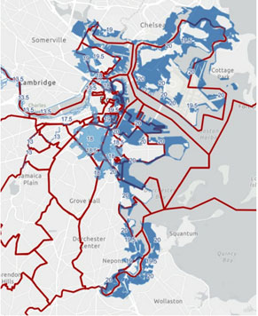
As part of The City of Boston’s commitment to climate resilience, on September 13, 2021, the Boston Planning & Development Agency (BPDA) approved Article 25A of the Boston Zoning Code. Article 25A provides a new Coastal Flood Resilience (CFR) Zoning Overlay District requiring new development and retrofits to take steps to limit building damages due to coastal storms and sea-level rise. The new zoning overlay includes areas beyond those identified in current FEMA flood maps. Based on climate modeling, Boston is anticipated to experience a 40-inch sea-level rise by 2070. The intent of the new overlay district is to facilitate flood resilient design and prevent flood damage by elevating buildings’ occupiable space and floodproofing areas beneath flood elevations.
The new zoning overlay allows for:
- Building heights to be measured from 2 feet above the Sea Level Rise Base Flood Elevation (SLR-BFE), rather than at grade.
- An allowance for side and rear yard encroachments for structures, such as stairs or ramps needed for vertical (access) circulation, due to a higher first floor elevation.
- An allowance for side and rear yard encroachments for new structures to house mechanical systems to ensure they are not located in basements or beneath the Sea Level Rise Design Flood Elevation (SLR-DFE).
- Structures needed for vertical circulation and mechanical systems referenced above will be excluded from measurement of lot coverage and open space.
- Gross Square Floor Area will exclude structures needed for vertical circulation and areas devoted to flood protection measures.
- Use of spaces below SLR-DFE are limited to access for vertical circulation structures, flood prevention measures, storage, and parking.
All projects that are subject to BPDA’s Article 80 large and small project review will be required to comply with the CFR Design Guidelines.

